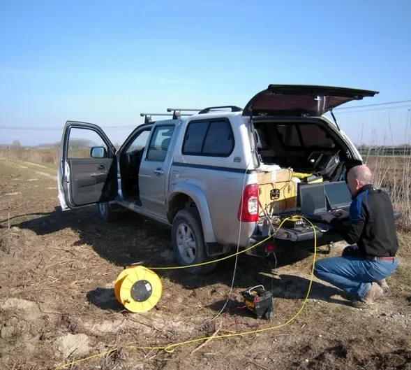
Sherbrooke sits at the confluence of the Magog and Saint-François rivers, with bedrock depths varying from less than 2 meters on the exposed Appalachian uplands to over 25 meters in the alluvial valleys. This geological contrast—hard quartzite and slate ridges adjacent to deep glacial and post-glacial sediments—means standard drilling alone rarely tells the full story. We apply seismic refraction and reflection methods to map overburden thickness, identify fractured zones, and locate the competent rock surface before any foundation design begins. Our field crews have worked across the boroughs, from the slopes near Mont-Bellevue to the industrial parks along Autoroute 410, and we know how the local Paleozoic formations behave under dynamic loading. When a project requires depth-to-bedrock certainty or detection of buried paleochannels that could compromise a deep excavation, seismic refraction provides continuous profiles that boreholes simply cannot achieve on their own.
In Sherbrooke's transitional geology, seismic velocity contrasts reveal what boreholes miss—buried channels, fractured ridges, and the true depth to competent rock.
Local ground factors
The freeze-thaw cycles that define an Eastern Townships winter—sometimes exceeding 100 cycles between November and April—create a weathered mantle of frost-shattered rock that can extend 1 to 3 meters below the surface on exposed ridges. This layer often exhibits P-wave velocities in the 1,200 to 2,000 m/s range, easily misidentified as dense till or highly fractured bedrock if the seismic line lacks sufficient resolution. We compensate by using short geophone spacing in the top spreads and running a few parallel lines with different source offsets to separate the frost zone from the true bedrock surface. The risk is not academic: foundations bearing partially on this seasonal crust and partially on intact rock experience differential settlement within the first two winters. Sherbrooke's history of moderate seismicity—the region sits within the Western Quebec Seismic Zone—adds a second layer of concern, because fractured, water-filled rock masses amplify ground motion in ways that uniform rock does not.
Relevant standards
NBCC 2020 (National Building Code of Canada, seismic provisions), ASTM D5777-18 (Standard Guide for Using the Seismic Refraction Method), ASTM D7128-18 (Standard Guide for Using the Seismic Reflection Method), CSA A23.3-19 (Design of Concrete Structures, referencing site classification), ASTM D7400-19 (Standard Test Methods for Downhole Seismic Testing, for cross-calibration)
Frequently asked questions
What is the typical cost of a seismic refraction survey in Sherbrooke?
For a standard site investigation with 2 to 4 refraction lines covering depths of 20 to 40 meters, budgets in the Sherbrooke area generally range from CA$3,890 to CA$7,630. The final figure depends on line length, number of spreads, terrain accessibility, and whether we acquire both P-wave and S-wave data. We provide a detailed proposal after reviewing the site plan and any existing borehole logs.
How deep can seismic methods see in the Sherbrooke region?
Refraction tomography reliably resolves the top 25 to 50 meters with a standard 115-meter spread and a weight-drop source. Reflection surveys, using longer spreads and stacked impacts, routinely image structure at 100 to 300 meters depth—sufficient for identifying buried valleys and deep fracture zones in the Appalachian basement. Actual penetration is energy-limited, so we match the source and spread to the target depth during survey design.
Can seismic tomography replace boreholes entirely?
It complements them rather than replacing them outright. Seismic velocity models provide continuous 2D cross-sections that connect borehole point data, revealing lateral changes a drilling program might miss. We still recommend at least one calibration borehole to anchor the velocity-to-geology conversion, especially where the contact between glacial sediments and weathered bedrock is gradational.
How does winter weather affect seismic data quality in the Eastern Townships?
Frozen ground increases near-surface velocities and can create a high-velocity lid that masks deeper arrivals. We account for this by acquiring data during thawed conditions whenever possible, or by using shorter geophone intervals and higher-energy sources to punch through the frozen crust. Processing includes static corrections and velocity filtering to isolate the frost effect from the underlying geology.
What deliverables do you provide after a seismic survey?
Every project includes processed seismic sections in both graphical and digital formats, a velocity-model report with ray-coverage diagnostics, a geotechnical interpretation correlating velocities to expected materials, and a site-classification summary aligned with NBCC 2020. We also supply raw field files and processing logs upon request for third-party review.