Sherbrooke's urban fabric, shaped by its industrial growth along the Magog and St. Francis rivers, presents a unique challenge for deep excavation. The city's expansion from its 19th-century core into surrounding hillsides has placed modern infrastructure directly over complex glacial and post-glacial deposits. At our accredited laboratory, we approach geotechnical excavation monitoring as a continuous dialogue with the ground. The Saint-François River valley, with its population of over 170,000, conceals sequences of dense till, sensitive Champlain Sea silty clay, and fractured shale bedrock that react unpredictably to stress relief. Before a single bucket is lifted, we integrate our monitoring program with the site's deep excavation design parameters, ensuring that real-time data feeds directly back into the observational method. The cold winters here, with average January lows reaching -15°C, add another dimension: freeze-thaw cycles can destabilize exposed cut faces within hours if not tracked with vigilant instrumentation.
Real-time pore pressure data from vibrating wire piezometers often reveals failure risk days before any visible crack appears on the shoring.
Local ground factors
The contrast between Sherbrooke's east and west sectors is stark when it comes to excavation risk. The eastern plateau, particularly around the former Ascot township, sits on a thick mantle of ablation till with abundant boulders that can deflect shoring piles and create hidden voids during drilling. The central valley, closer to the Magog River gorge, is underlain by deep, compressible Champlain Sea clay where basal heave is the primary concern. If the excavation base is not adequately dewatered or if the clay's undrained shear strength is overestimated, the floor can bulge upward rapidly. In the rock-controlled zones of Lennoxville, the slate and shale bedrock is highly anisotropic; relief along foliation planes during a cut can trigger block failures that no conventional monitoring plan would catch without targeted extensometers. Our monitoring programs address these localized risks by tailoring the instrumentation layout to the specific geomorphological unit, not a generic city-wide template.
Frequently asked questions
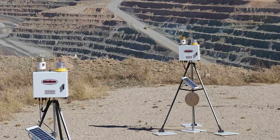
What specific instruments are used for excavation monitoring in Sherbrooke's clay soils?
For the Champlain Sea clay deposits common in the valley, vibrating wire piezometers are essential because they provide stable, long-term pore pressure readings without the lag time of standpipes. In-place inclinometers with MEMS sensors allow continuous, automated monitoring of lateral deformation at the shoring face. We also use magnetic extensometers for basal heave detection and robotic total stations for optical prism monitoring on adjacent buildings.
What is the typical cost range for a 6-month monitoring program on a downtown Sherbrooke excavation?
A comprehensive 6-month program, including installation of 2 inclinometers, 3 vibrating wire piezometers, and weekly manual survey readings with a report dashboard, generally ranges from CA$1,070 to CA$3,820 depending on access constraints and the number of automated readout units required. Complex sites requiring real-time telemetry fall at the upper end.
What are the key NBCC requirements for monitoring adjacent structures during deep excavation?
The NBCC 2015 and referenced CSA S6-19 require the engineer to establish threshold values for settlement and angular distortion. For typical masonry buildings in Sherbrooke's older boroughs, we often set a settlement trigger at 10 mm and an angular distortion limit of 1/500. The code mandates that monitoring frequencies increase when measured values approach these thresholds, and that all data be documented for the geotechnical engineer of record.